


All eyes will be on the Atlantic tropics over the coming days, as an area of investigation known as Invest 95L is currently forecast, by a number of models, to have the potential to become a hurricane in the Caribbean and perhaps head towards the Gulf of Mexico. See the latest updates here.
Already, some catastrophe bond and insurance-linked securities (ILS) fund managers have cited this potential area of concern.
First to do so was Twelve Capital, with the catastrophe bond and reinsurance-linked asset manager saying, “In the Atlantic, there are currently two potential areas of development over the next seven days, one in the Caribbean Sea with a 20% chance, and an area out in the Main Development Region (middle of the Atlantic Ocean), with a 70% chance of development into a storm system. Should either of these areas develop into a Named Storm, the potential strength and direction of these areas will become clearer over the coming days.”
It is the second area mentioned, in the Main Development Region (MDR) of the Atlantic, that is the more significant concern, as this is Invest 95L and some models suggest it could have a run at attaining major hurricane status, with Category 3 wind speeds or higher.
Next to comment was cat bond fund manager Icosa Investments, stating, “Currently, there is such a disturbance designated AL95 on the move. While it’s still early, and forecasts are evolving with each model update, this system could become the first significant storm of the season. Most models agree that AL95 will reach tropical storm status within the next 48 to 72 hours, likely being named “Beryl”. Beyond that, model predictions vary regarding its path and intensity.”
Icosa Investments highlighted that there is a broad spread in the models currently, in terms of the eventual path and intensity of this area of development, ranging from parts of the Caribbean, to Mexico and then if it makes it through that region into the Gulf of Mexico, with anywhere from Texas to Florida a potential destination for the disturbance should it achieve tropical storm or hurricane status and follow that path.
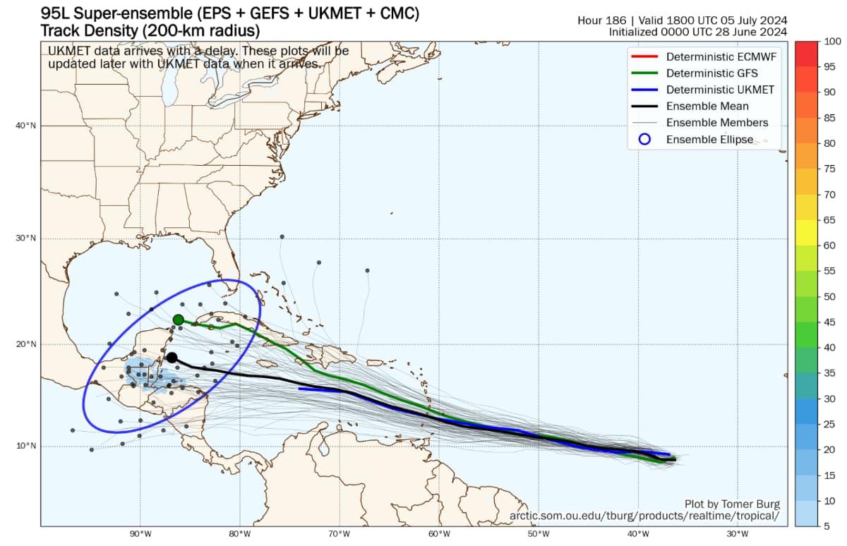
We’ve looked at one helpful model visualisation from Tomer Burg, which shows the spread of ensemble models at approximately one week out from now (seen below).
But Icosa Investments also rightly highlights the potential for this system to intensify, as some models are taking it into the upper categories of hurricane strength and intensity, although uncertainty is significant here.
Icosa Investments explained that, “What’s particularly interesting is that some models suggest environmental conditions are favorable enough for this system to potentially reach Category 4 status. If this happens, it would mark an unusually early major hurricane for the season.
“However, the accuracy of these early model runs is limited, and more time and data are needed for a precise forecast. Also, most models do not anticipate strengthening of this system to that extent.”
Below you can see Levi Cowan’s model intensity guidance graphic for invest 95L, which shows a number of model runs indicating the potential for strong wind speeds from this storm in future.

We are still five days to a week out from having any greater certainty over this area of development and any potential threats. But, right now, the GFS and ECMWF models both show a tropical system in the Caribbean, with the GFS taking it close to the Antilles, while the ECMWF tracks further south and takes the system into Mexico (other models have a wide range in between).
The HWRF hurricane model deepens what would be tropical storm Beryl and then hurricane Beryl to 940 mb or lower as it tracks through the Caribbean, although that is the most aggressive looking model output we’ve seen so far.
Some models have Invest 95L (potential Beryl) followed closely by another tropical system on a very similar path, both tracking through the Caribbean and with the potential to head towards the Gulf of Mexico.
It’s important to note these model runs are still a long way out and there is little confidence in their outputs at this time.
But, this is the first hurricane threat of the 2024 Atlantic season that has meteorologists watching closely, as well as catastrophe bond and ILS fund managers, no doubt the rest of the reinsurance industry as well.
More will be known on the potential for tropical storm Beryl to form and for any intensification to occur over the next few days.
At this time, the National Hurricane Center gives a 90% chance tropical storm Beryl forms within 7 days, an 80% chance it happens within 2 days from now.
So, to sum up, the second named tropical storm of the Atlantic season looks to have a relatively high probability of forming over the next few days, but significant uncertainty exists over its eventual track and intensity for the time beyond that.
As a result, all eyes will be on the tropics for the next few days and as ever you can track the 2024 Atlantic tropical storm and hurricane season on our dedicated page and we’ll update you as any new information emerges.
Update 1 – Jun 28th: The NHC has now upgraded the area of investigation to a tropical depression, also saying it is expected to attain hurricane strength.
So it seems we will have tropical storm Beryl likely in the coming hours and hurricane Beryl shortly after.
The NHC said, “Maximum sustained winds are near 35 mph (55 km/h) with higher gusts. Steady strengthening is forecast, and the depression is expected to become a tropical storm tonight or early Saturday and a hurricane in a couple of days.”
Updates – Jun 29th:
Tropical storm Beryl was named overnight and the forecast is for the storm to intensify to become hurricane Beryl within the next day.
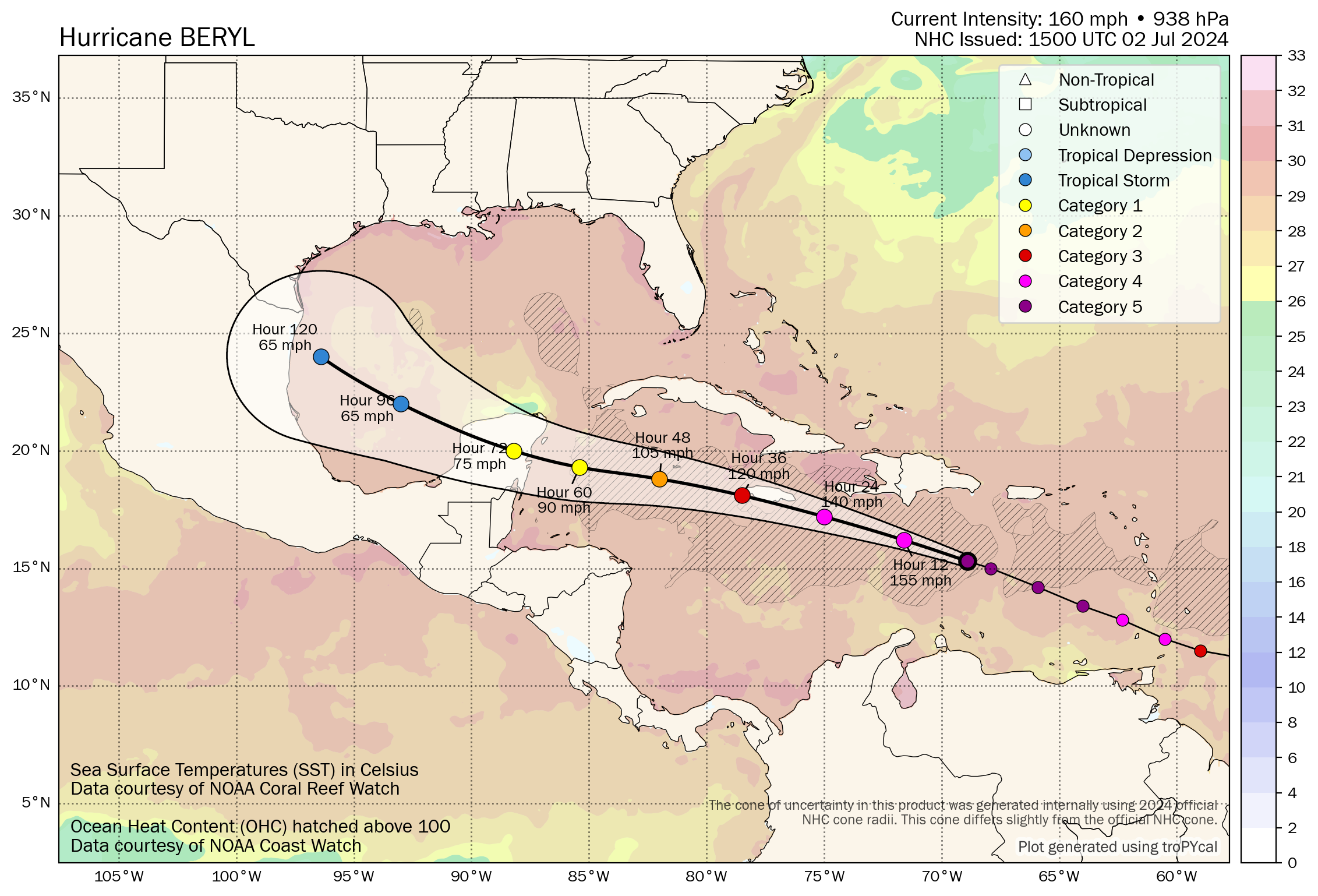
Longer-range forecasts suggest hurricane Beryl will top out at category 3 currently, with winds of around 115 mph.
The forecast path for what is anticipated to become hurricane Beryl takes the storm through the Windward Islands into the Caribbean and tracks it south of the Antilles towards Jamaica.
As you can see, rapid intensification is forecast, with a chance of hurricane Beryl reaching Category 3 status before reaching the Windward Islands. Interests on the islands should watch the storm closely, as if it comes close to any of them there could be a significant threat to lives and property.
After the Windward Islands, the next landmass in Beryl’s forecast path is Jamaica. Hurricane Beryl is currently forecast to sustain Category 3 major storm status for over 24 hours, but then weaken slightly as it moves closer to Jamaica.
Forecast data suggests hurricane Beryl could near Jamaica still with wind speeds of over 100 mph.
Of course, Jamaica has a parametric catastrophe bond in-force today, the $150 million IBRD CAR Jamaica 2024 transaction.
While that parametric cat bond is exposed to hurricanes, details seen by Artemis suggest a storm of category 3 or greater could be required in order to trouble the notes.
In order for Jamaica’s parametric World Bank cat bond to face losses from a hurricane, it would need to be in the upper ranges of Category 2 wind speeds, with a minimum central pressure of 969mb or lower, we believe.
There are modelled examples of Category 2 storms that could cause a partial payout on these notes, but the hurricane would need to deepen its central pressure below that 969mb level and pass through a central region of Jamaica, passing close to areas of greater exposure such as Kingston, in order to activate the parametric trigger.
At this time a threat to Jamaica’s World Bank catastrophe bond cannot be ruled out though, as the latest forecast updates have seen Beryl intensify faster and maintain stronger winds for longer than the forecasts just 12 hours ago.
It is still far too early to tell of any threat to Jamaica’s catastrophe bond, as Beryl is not yet a Category 1 hurricane, let alone of the strength needed to concern noteholders.
The latest forecast suggests Beryl could still be mid-strength Category 2 hurricane with winds of around 100 mph when it gets closer to Jamaica. But the latest forecast data also takes hurricane Beryl slightly further south and offshore of Jamaica, than this mornings forecasts did.
But it is still going to be important to watch hurricane Beryl as it develops, intensifies and any land interaction in the Windward Islands could also degrade the storm a little and affect its track. So a lot still needs to play out before the market will have a better idea of any threat to the only cat bond currently in Beryl’s path.
Further out, models differ somewhat on Beryl’s future, with some suggesting it cross the Yucatan peninsula and then emerges into the Gulf of Mexico to intensify before a landfall in northern Mexico or southern Texas. Other models point to the area of development following in Beryl’s wake, which they suggest could actually pose more of a Gulf threat. But that all remains a long-way out at this time and it remains to be see if there is any US threat from Beryl or what storm follows behind.
As expected, Beryl was named as a hurricane around 16:30 EST and is expected to rapidly intensify.
It’s worth reading the full article for more context, but the latest updates are below.
Hurricane Beryl has been strengthening over night and is now expected to become a major Category 3 storm when it nears the Windward Islands and moves into the Caribbean.
As we moved into June 30th, the main forecast models had largely shifted the forecast track for hurricane Beryl a little further south, which could mean the storm is further away from Jamaica as it passes in a could of days. But there is plenty of time for the track to shift back again, so holders of the World Bank cat bond that covers Jamaica will still be watching carefully.
Most forecast models take hurricane Beryl into the Yucatan peninsula at this time, but with reconnaissance aircraft set to enter the storm today better information and data should be available, and we could see some of the forecast path predictions shifting as a result.
Meaning we could have a better and more accurate view of the future path and intensity of hurricane Beryl later today, or tomorrow, with greater certainty over whether any threat to the United States could emerge if the storm makes its way into the Gulf.
As Sunday progressed, hurricane Beryl intensified to become a dangerous Category 4 storm with sustained winds of 130 mph and higher gusts.
The Windward Islands are facing a potentially dangerous situation, with Grenada closest to the current forecast path for hurricane Beryl. Grenada, St Vincent and the Grenadines are the most exposed to the current path and expected to face the most dangerous impacts if Beryl moves close to them as it tracks west.
The NHC warns of life-threatening winds with gusts of up to 150 mph and storm surge of 6 to 9 feet above normal sea levels, with localised rainfall amounts of as much as 10 inches possible as well.
There is still uncertainty as to hurricane Beryl’s path once it clears the Windward Islands and any land interaction or impacts could have an effect on its future path and intensity, so the outlook for the Gulf Coast of the US will be better known by middle of the week it seems.
Jamaica remains on-watch, but still the forecast path is for Beryl to pass to the south, although wind speed forecasts suggest the storm could still be at or near Category 3 at that time, so should Beryl track closer to Jamaica then the country’s catastrophe bond may come more into focus.
It’s worth noting that the HWRF hurricane model takes hurricane Beryl to a direct landfall in Jamaica at around 950mb, which would be a concerning scenario for holders of the Jamaican catastrophe bond notes, as well as for that country and its population.
There is also the Yucatan scenario that a number of models show to consider, with Mexico having just completed issuance of another cat bond to provide Atlantic hurricane protection this year.
The HWRF model, however, also takes hurricane Beryl between Cuba and the Yucatan and directly into the Gulf of Mexico, which would also be a concerning scenario for Gulf Coast residents, with a potential hurricane threat for the United States as a result.
One final point worth mentioning, is that the ECMWF hurricane model also shows hurricane Beryl taking a more northerly route through the Caribbean and impacting Jamaica, albeit at lower intensity than the HWRF suggests.
So, it’s important to watch Beryl over the next few days and the tracks once the storm has got into the Caribbean proper should provide more information as to how much of a threat this hurricane poses to Jamaica and the United States.
On the morning of July 1st, major hurricane Beryl was continuing towards the Windward Islands and threatening a devastating blow should it pass close by or its core make landfall there.
The warnings from the NHC have not changed much, with sustained winds estimated slightly lower at 120 mph, but gusts are estimated to reach above 160 mph now, with Beryl remaining a very dangerous hurricane. The current forecast data suggests hurricane Beryl will strengthen again to become a Category 4 storm after it passes the Windward Isles.
The map below is from Tomer Burg’s excellent resources (click it for the very latest version).
Hurricane Beryl’s storm surge is still estimated to reach 6 to 9 feet above sea level, while rainfall totals for the islands are still seen as up to 10 inches from the storm.
The latest forward track modelling information takes hurricane Beryl a little closer to Jamaica again, although still likely far enough offshore at this time not to trigger the World Bank catastrophe bond for that country.
But with almost 3 days before the storm reaches Jamaica, there is still plenty of time for the track to shift further north, so this will need watching over the start of this week.
For the Mexico catastrophe bond’s Atlantic hurricane cover to trigger, it seems hurricane Beryl would need to deepen somewhat and have a much lower central pressure, than the 965mb it is reported with today, for even a 25% loss of principal to occur. But, this cat bond will also be on-watch through the start of this week, as hurricane Beryl passes the Windward Islands and moves deeper into the Caribbean.
It’s also worth noting that the HWRF hurricane model has shifted further south again today, in its latest runs, taking Beryl offshore of Jamaica again, although the ECMWF continues to track much closer to that island.
Finally for this morning, it’s worth highlighting the records hurricane Beryl has broken, being the earliest category 4 Atlantic hurricane on record, the first major hurricane east of the Lesser Antilles on record for June, and is being cited as an extremely rare occurrence for this time of the year.
As of middle of the day on July 1st, the National Hurricane Center said that hurricane Beryl had regained its Category 4 status with 130 mph sustained winds, while its minimum central pressure was deeper at 956mb.
The Windward islands of the Grenadines and St. Vincent remain the most exposed to hurricane Beryls’ strongest winds, based on the current forecast path and these islands look set to receive a damaging assault from the major hurricane in the coming hours. All thoughts are with the people of those islands at this time.
The National Hurricane Center has further upgraded hurricane Beryl’s wind speeds, saying that reconnaissance aircraft have found the storm stronger still, with now 150 mph sustained winds and a deeper central pressure at 950mb.
Wind gusts are estimated at over 166 mph, as of the latest forecast advisory today, meaning hurricane Beryl continues to intensify and is an extremely dangerous storm for the Windward Islands.
Major hurricane Beryl is deemed to have made landfall on Carriacou Island, becoming the second most powerful storm on record to have made landfall in the Windwards.
Read the latest updates in this new article on hurricane Beryl.
![]() View all of our Artemis Live video interviews and subscribe to our podcast.
View all of our Artemis Live video interviews and subscribe to our podcast.
All of our Artemis Live insurance-linked securities (ILS), catastrophe bonds and reinsurance video content and video interviews can be accessed online.
Our Artemis Live podcast can be subscribed to using the typical podcast services providers, including Apple, Google, Spotify and more.


